
Meteorological Service of Canada
Type of resources
Topics
Keywords
Contact for the resource
Provided by
Years
Formats
Representation types
Update frequencies
status
-
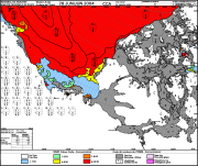
This daily forecast describes the ice edge using latitude and longitude coordinates, the total ice concentration, the predominant ice stage of development and the concentration of the oldest ice type. Warnings are issued as appropriate. The forecasts are valid from the time of issue until the end of the following day (so for a period of 24 to 48 hours).
-
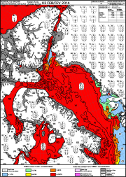
These ice charts illustrate ice conditions at a particular moment in time. The ice information is presented using a standard international code, known as the Egg Code. The following charts are available from the Canadian Ice Service: -Daily Ice Charts -Image Analysis Ice Charts -Regional Ice Charts
-
The Canadian Ice Service maintains a collection of Daily ice charts, Regional ice charts and Iceberg charts. These charts are available in GIF format and E00 (Regional Charts only).
-
This daily forecast describes the ice edge using latitude and longitude coordinates, the total ice concentration, the predominant ice stage of development and the concentration of the oldest ice type. Warnings are issued as appropriate. The forecasts are valid from the time of issue until the end of the following day (so for a period of 24 to 48 hours).
-
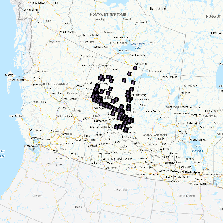
Water level and discharge data are available from Water Survey of Canada’s Hydrometric Network. The Water Survey of Canada (WSC) is the national authority responsible for the collection, interpretation and dissemination of standardized water resource data and information in Canada. In partnership with the provinces, territories and other agencies, WSC operates over 2500 active hydrometric gauges across the country, maintains an archive of historical information for over 7600 stations and provides access to near real-time (water level and stream flow) provisional data at over 1700 locations in Canada.
-
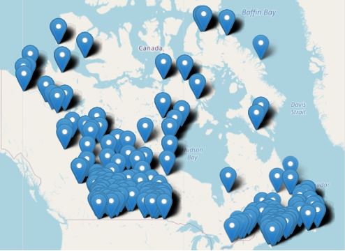
Meteorological Observations describe datasets that contain information aboutweather and climate conditions as available on the City-Pages of the Environment Canada WeatherOffice.gc.ca web site. These pages contain information about current weather conditions and past climate including temperature, wind, and humidity measurements, written descriptions of current conditions, rain and snow amounts, average and extreme temperatures, etc. The current conditions are acquired from a variety of observing system operators and are provided in near-real time with limited quality assurance. Current condition information should not be considered as quality-controlled official values. The availability of values for every observation period is not guaranteed as they may be affected by observing system operations.
-
The Regional Air Quality Deterministic Prediction System FireWork (RAQDPS-FW) carries out physics and chemistry calculations, including emissions from active wildfires, to arrive at deterministic predictions of chemical species concentration of interest to air quality, such as fine particulate matter PM2.5 (2.5 micrometers in diameter or less). Geographical coverage is Canada and the United States. Data is available at a horizontal resolution of 10 km. While the system encompasses more than 80 vertical levels, data is available only for the surface level. The products are presented as historical, annual or monthly, averages which highlight long-term trends in cumulative effects on the environment.
-
Climate Data Products at Environment Canada comprise of four different datasets: Almanac Averages and Extremes, Monthly Climate Summaries, Canadian Climate Normals, and Canadian Historical Weather Radar. Almanac Averages and Extremes provides average and extreme temperature and precipitation values for a particular station over its entire period of record. Monthly Climate Summaries contains values of various climatic parameters, including monthly averages and extremes of temperature, precipitation amounts, degree days, sunshine hours, days without precipitation, etc. Canadian Climate Normals are used to summarize or describe the average climatic conditions of a particular location. Data is available for stations with at least 15 years of data between the periods of 1961-1990, 1971-2000 and 1981-2010. Canadian Historical Weather Radar compirses of historical images from the radar network providing a national overview of where percipitation is occuring.
-
A Virtual Climate station is the result of threading together climate data from proximate current and historical stations to construct a long term threaded data set. For the purpose of identifying and tabulating daily extremes of record for temperature, precipitation and snowfall, the Meteorological Service of Canada has threaded or put together data from closely related stations to compile a long time series of data for about 750 locations in Canada to monitor for record-breaking weather. The length of the time series of virtual stations is often greater than 100 years. A Virtual Climate station is always named for an “Area” rather than a point, e.g. Winnipeg Area, to indicate that the data are drawn from that area (within a 20km radius from the urban center) rather than a single precise location.